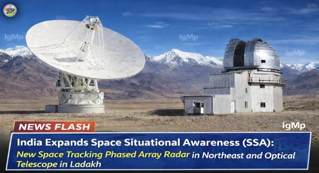
As per the report of WION, Indian Space Research Organisation (ISRO) is quietly restructuring the country’s Space Situational Awareness (SSA) architecture with a geographically and technologically complementary network—pairing an indigenous Phased Array Radar system in the Northeast with a high-altitude optical telescope in Hanle.
This dual-mode expansion addresses a critical vulnerability in India’s orbital monitoring capability: the inability of a single sensor type to provide continuous, all-condition tracking in an increasingly congested Low Earth Orbit (LEO).
Technical Breakdown: Why a Dual-Mode SSA Network Matters
India’s next-generation Space Situational Awareness (SSA) framework is built on a simple but powerful principle—no single sensor can track everything, all the time.
Radar Systems (Northeast Deployment)
- Operate in all weather conditions
- Provide precise range and velocity data
- Capable of 24/7 tracking, including during cloud cover and daylight
- Designed using indigenous phased array technology, enabling rapid beam steering
The planned Northeast radar—reviewed by a national expert committee in 2025—is expected to fill a major eastern coverage gap in India’s orbital tracking geometry.
Optical Systems (Hanle, Ladakh)
- Offer high-resolution imaging for object identification
- Operate best under low atmospheric attenuation and minimal light pollution
- Ideal for tracking objects using reflected sunlight, especially during twilight/night
Hanle’s high-altitude desert environment makes it one of the best optical observation sites in Asia, significantly improving detection accuracy for smaller debris and satellites.
How does ISRO’s new phased array radar improve space safety?
The Northeast radar is designed to complement existing infrastructure like the Multi-Object Tracking Radar (MOTR) at Sriharikota, which operates in the L-band—a crucial technical detail for long-range tracking.
MOTR already demonstrates the ability to track objects as small as 0.25 square meters at distances up to 1,000 km, placing it squarely within the most critical orbital band.
This 500 km–1,000 km altitude range represents the primary congestion zone in LEO, where:
- Earth observation satellites operate
- Collision risks are highest
- Debris accumulation is accelerating
By adding a Northeast radar node, India enhances orbital revisit rates, reduces blind spots, and improves real-time collision prediction.
Why was Hanle, Ladakh chosen for India’s new space telescope?
The selection of Hanle is not incidental—it is rooted in atmospheric science.
Located at over 4,500 meters altitude, Hanle offers:
- Extremely low atmospheric attenuation
- Near-zero industrial light pollution
- Stable atmospheric conditions ideal for precision optics
These factors dramatically improve the performance of optical SSA systems, allowing clearer imaging of satellites and debris—something radar alone cannot achieve.
This makes Hanle a critical node for object characterization, especially when distinguishing between operational satellites and hazardous debris.
What is the significance of the Baker Nunn Schmidt Telescope refurbishment?
India is also upgrading legacy infrastructure like the Baker Nunn Schmidt Telescope (BNST) at Nainital.
Originally designed for satellite tracking during the early space age, BNST is being modernized to:

- Support wide-field optical tracking
- Provide redundancy and cross-verification
- Integrate into a broader SSA data network
This refurbishment reflects a strategic shift—leveraging both legacy assets and modern systems to build a resilient tracking ecosystem.
Comparison: India’s Emerging Space Situational Awareness (SSA) Network
| Facility | Technology Type | Primary Advantage | Status |
|---|---|---|---|
| Northeast Radar | Indigenous Phased Array | All-weather, 24/7 tracking | Review completed (2025) |
| Hanle Telescope | Optical System | High-altitude, clear-sky precision | Installation phase |
| MOTR (Sriharikota) | L-Band Active Phased Array | Tracks 0.25 sqm objects at 1000 km | Operational |
| BNST (Nainital) | Baker Nunn Schmidt | Complementary optical tracking | Refurbishing |
The Strategic Logic: Filling Temporal and Atmospheric Gaps
The real strength of this architecture lies in complementarity:
- Radar-only systems struggle with object identification and fine shape resolution
- Optical-only systems fail during daylight and adverse weather
By combining Northeast radar coverage with Ladakh’s optical precision, India achieves near-continuous temporal coverage—day, night, and across seasons.
This “Northeast + Ladakh” configuration effectively closes both:
- Atmospheric gaps (clouds, light interference)
- Temporal gaps (day vs night tracking limitations)
A Shift Toward Layered Space Surveillance
Rather than expanding in isolation, ISRO’s evolving SSA network reflects a layered surveillance philosophy—integrating radar, optical, and legacy systems into a unified tracking grid.
As LEO becomes increasingly crowded, especially in the 500–1,000 km band, this hybrid model positions India to:
- Improve collision avoidance capabilities
- Strengthen satellite protection
- Enhance strategic space awareness
In an era of orbital congestion and rising debris risks, India’s approach signals a clear shift—from passive monitoring to active space domain awareness.